
Talybont Flood Alleviation Scheme
This consultation closed on 28 February 2025.
The responses to this consultation are currently being reviewed. Details of the outcome will be published here in due course.
Original consultation
A scheme is being developed for the Talybont area in response to a fluvial flood event on 8th to 9th June 2012, where a month’s worth of rainfall fell within 24 hours. Flood depths of up to 1.5m were recorded and this caused damage to up to 27 residential properties. The flooding also resulted in the closure of the A487 for several hours.
This was estimated to be a severe event with a return period of 1 in 200 years (0.5% (AEP) event). There are also concerns with debris blocking the A487 crossing and gravel washed down the river reducing channel capacity.
Annual Exceedance Probability (AEP) refers to the probability of a flood event occurring in any year. The probability is expressed as a percentage. For example, a large flood which may be calculated to have a 1% chance to occur in any one year, is described as 1% AEP.
The table below shows that the onset of flooding in the 'Business as Usual' scenario happens during the 50% AEP flood event with two residential properties predicted to be at risk of flooding. This rises to 31 residential properties and three non-residential properties during the 1% AEP event. With climate change, in the 2080s epoch, the total number of residential and non-residential properties at risk rises to 34 and three respectively.
| Option | Property Type | 50%AEP (1:2yr) | 20%AEP (1:5yr) | 10%AEP (1:10yr) | 3.33%AEP (1:30yr) | 2%AEP (1:50yr) | 1.33%AEP (1:75yr) | 1%AEP (1:100yr) | 0.5%AEP (1:200yr) |
| Business as Usual (Present Day) | Residential | 2 | 15 | 25 | 27 | 29 | 29 | 31 | 34 |
| Non-residential | 0 | 1 | 2 | 3 | 3 | 3 | 3 | 3 | |
| Business as Usual (2020s) | Residential | 2 | 18 | 27 | 27 | 30 | 30 | 32 | 34 |
| Non-residential | 0 | 1 | 2 | 3 | 3 | 3 | 3 | 3 | |
| Business as Usual (2050s) | Residential | 15 | 27 | 27 | 31 | 32 | 34 | 35 | 35 |
| Non-residential | 0 | 3 | 3 | 3 | 3 | 3 | 3 | 3 | |
| Business as Usual (2080s) | Residential | 17 | 27 | 27 | 32 | 32 | 34 | 34 | 36 |
| Non-residential | 1 | 3 | 3 | 3 | 3 | 3 | 3 | 3 |
In the Walkaway scenario (if Ceredigion County Council chooses to disengage or abandon the project), there are 15 residential properties and one non-residential property at risk during the 2-year flood event rising to 34 residential and three non-residential during the 100-year event. When climate change is considered, this increases to 36 residential and three non-residential during the 100-year event.
| Option | Property Type | 50%AEP (1:2yr) | 20%AEP (1:5yr) | 10%AEP (1:10yr) | 3.33%AEP (1:30yr) | 2%AEP (1:50yr) | 1.33%AEP (1:75yr) | 1%AEP (1:100yr) | 0.5%AEP (1:200yr) |
| Walkaway (Present Day) | Residential | 15 | 25 | 27 | 29 | 29 | 31 | 34 | 34 |
| Non-residential | 1 | 2 | 3 | 3 | 3 | 3 | 3 | 3 | |
| Walkaway (2020s) | Residential | 18 | 27 | 27 | 30 | 30 | 32 | 34 | 34 |
| Non-residential | 1 | 2 | 3 | 3 | 3 | 3 | 3 | 3 | |
| Walkaway (2050s) | Residential | 27 | 27 | 31 | 32 | 34 | 35 | 35 | 35 |
| Non-residential | 3 | 3 | 3 | 3 | 3 | 3 | 3 | 3 | |
| Walkaway (2080s) | Residential | 27 | 27 | 32 | 32 | 34 | 34 | 36 | 36 |
| Non-residential | 3 | 3 | 3 | 3 | 3 | 3 | 3 | 3 |
The 2016 hydraulic model was used to assess the baseline scenario and to further understand flood risk. The results and other documentation were used to inform a list of potential options that could manage flooding. Each option was assessed for advantages and disadvantages in terms of technical viability, health and safety risks, buildability, environmental impacts and opportunities, and stakeholder support.
The table below shows the outcomes of this exercise.
| Scenario | Total score (before weighting) | Total weighted score |
| Walkaway (disengage or abandon the project due to critical conditions, excessive risks, or diminishing benefits) | -1005.0 | -2001.2 |
| Business as Usual (day-to-day operations and processes that continue to function without any significant changes or disruptions) | -2.0 | -2.2 |
| DS01 - Upstream offline flood storage areas | 6.0 | 5.3 |
| DS02 - Upstream offline flood storage areas on Rivers Leri and Ceulan, bridge upsizing and removal of existing weirs | 9.0 | 10.3 |
| DS03 - Upstream online flood storage areas on River Leri, bridge upsizing and removal of existing weirs | 6.0 | 5.7 |
| DS04 -Upstream online and offline flood storage areas, bridge upsizing and removal of existing weirs | 7.0 | 7.0 |
| DS05 -Re-activate old Mill Channel on River Leri and connect to new flood relief culvert, upstream online and offline flood storage areas, bridge upsizing and removal of existing weirs | 0.0 | 1.0 |
| DS06 -Upstream flood storage areas plus Natural Flood Risk Management | 10.0 | 7.2 |
| DS07 - Upstream flood storage areas plus River Restoration measures | -7.0 | 6.0 |
| DS08 - Raised flood walls along River Ceulan and Leri watercourse | 5.0 | -2.8 |
| DS09 - Raised flood walls along River Ceulan and Leri watercourse plus Natural Flood Risk Management | 0.0 | 3.1 |
| DS10 - Two-stage channel lengths on River Leri and Ceulan, bridge upsizing and removal of existing weirs | -4.0 | -1.2 |
| DS11 - Modifications to Craig-y-Pistyll reservoir, upstream flood storage plus Natural Flood Risk Management | 12.0 | -2.3 |
| DS12 - Upstream flood storage areas, Natural Flood Risk Management and River Restoration | 0.0 | 8.6 |
The result is a short list of five options. These are the options we are consulting on.
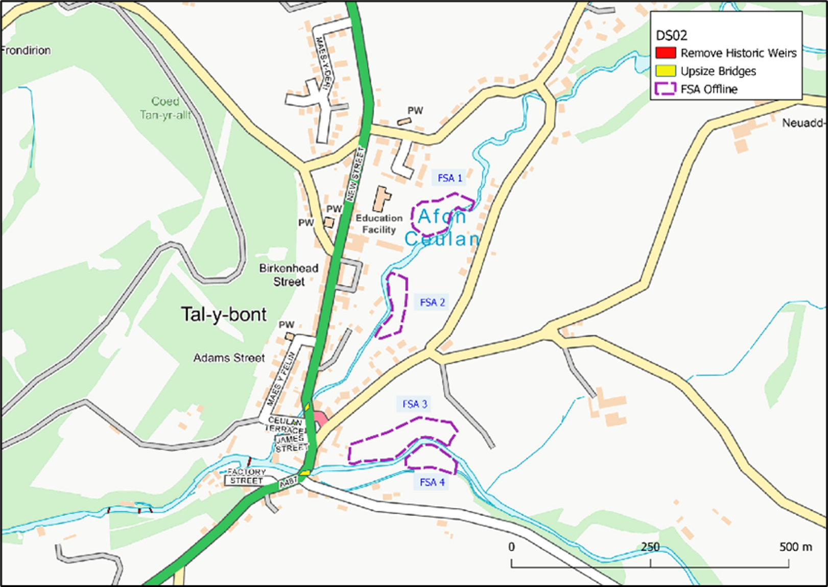
Option 1 (DS02) – Upstream Offline Flood Storage Areas on Rivers Leri and Ceulan, Bridge Capacity Expansion and removal of existing weirs
Four storage areas would be designed to impound and retain water during a flood event, reducing the peak levels of flooding downstream, before releasing water back into the river at a controlled rate once the river levels have reduced.
Construction of the storage areas would involve the excavation of significant volumes of material, and whilst most would be reused on site to create new bunds, there would be a requirement for some material to be disposed off site. Each storage area site is close to existing roads, but some short lengths of temporary access routes would be required.
This option appreciably reduces flood depths within Tal-y-bont compared to the 'Business as Usual' baseline, allowing Property Level Protection measures to become viable for many properties up to the 1 in 100 year event. There is a particular improvement to flood outlines upstream of the A487 Afon Ceulan bridge where flooding is removed in all return periods up to the 1 in 200 year event. This is likely due to the upsizing of the bridge in this location. The depths of flooding are also substantially reduced on Afon Leri downstream of the A487.
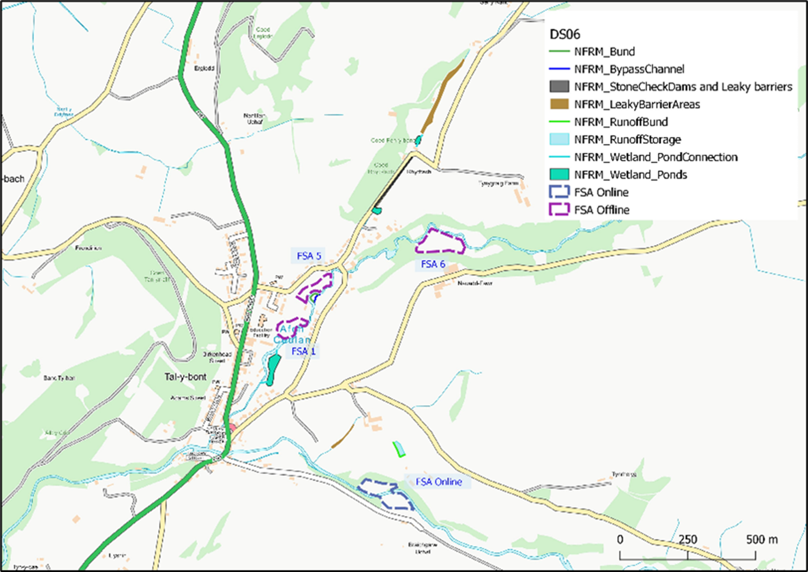
Option 2 (DS06) - Upstream Flood Storage Areas plus Natural Flood Risk Management
These flood storage areas would comprise three offline areas, and one online area. The offline areas would function and be constructed in a similar way to that discussed above.
The remaining online storage area would be constructed by building a bund across the channel, with a culvert to allow forward unimpeded passage for this river during normal flows. During high rainfall events, water would be retained behind the bunds and allowed to spill onto both banks.
Further upstream on this watercourse, within the wooded section north of Rhydfach, leaky woody debris dams would be installed along the watercourse. These would retain and slow the flow of water during times of high flows, but allow normal low flows to pass unimpeded beneath the dams. A new pond would be constructed downstream of the dam features.
A large offline pond would be constructed on the left bank of the Afon Ceulan, connected upstream and downstream to the river. This would function in a different way to the flood storage areas, as it would be permanently wet to provide a habitat for wildlife and give other ecological and water quality benefits.
This option reduces flood depths within Talybont, but to a lesser extent than Option 1 above. Notably the flood reduction east of the Afon Ceulan A487 bridge is not present in this option. The flood outlines are similar to that of the Business As Usual scenario with only a very small reduction in area.
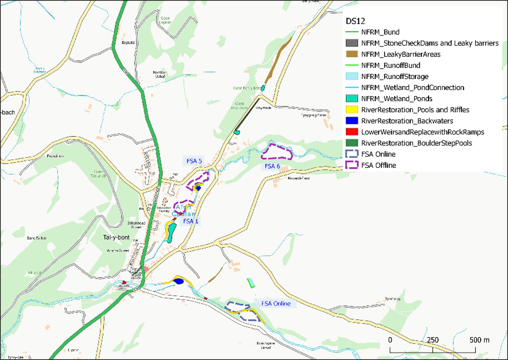
Option 3 (DS12) - Upstream flood storage areas, Natural Flood Risk Management and River Restoration
This option includes the same Flood Storage Areas as those discussed as part of Option 2, as well as some of the Natural Flood Risk Management (NFRM) elements
A section of new boulder step pools would be constructed along the Afon Ceulan channel between James Street and the A487, where the watercourse is enclosed by riparian owned retaining walls. This would help to protect the existing channel walls from scour and erosion, allow finer sediment to settle in the channel, and slow the flow of water along this section.
The existing weirs in the upstream section of the Afon Ceulan above Talybont would be lowered to bed level, and each replaced with a rock ramp to maintain the level differences. The replacement of these weirs would improve fish passage in the watercourse, allow for natural movement of sediments, and lower water levels upstream, allowing greater capacity for storage during high rainfall events.
Additional storage and environmental benefits would also be created through the construction of two new backwaters; one on a bend of the left bank of the Afon Ceulan, and the second along the redundant Mill Race on the southern bank of the Afon Leri. These backwaters would be permanently wet to create new habitats, but have raised banks to ensure further storage capacity during flood events.
Pool and riffle features would also be constructed along suitable sections of the Afon Ceulan and Afon Leri. These would provide environmental enhancements to the river, creating different flow regimes within the river and providing spawning areas for fish.
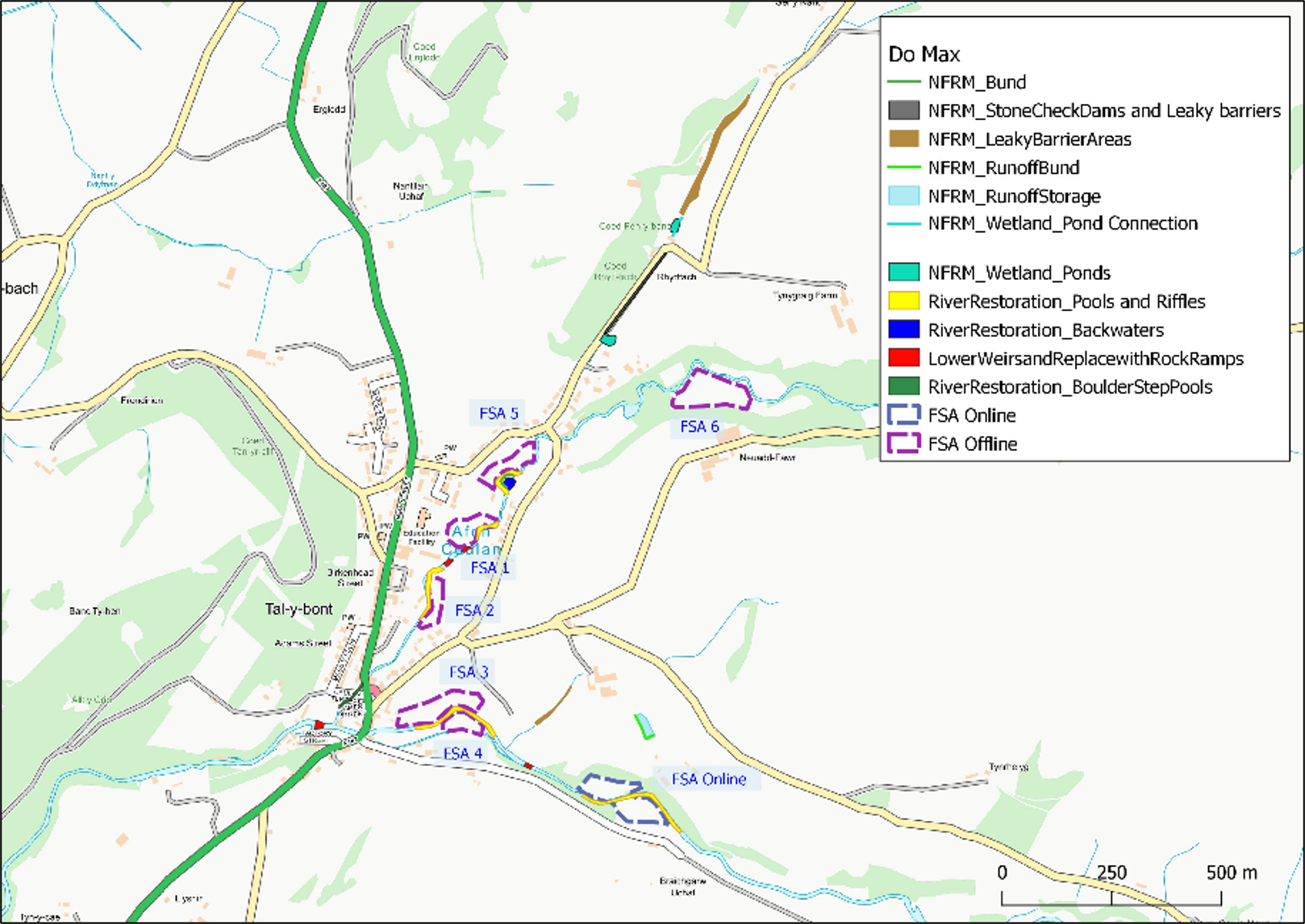
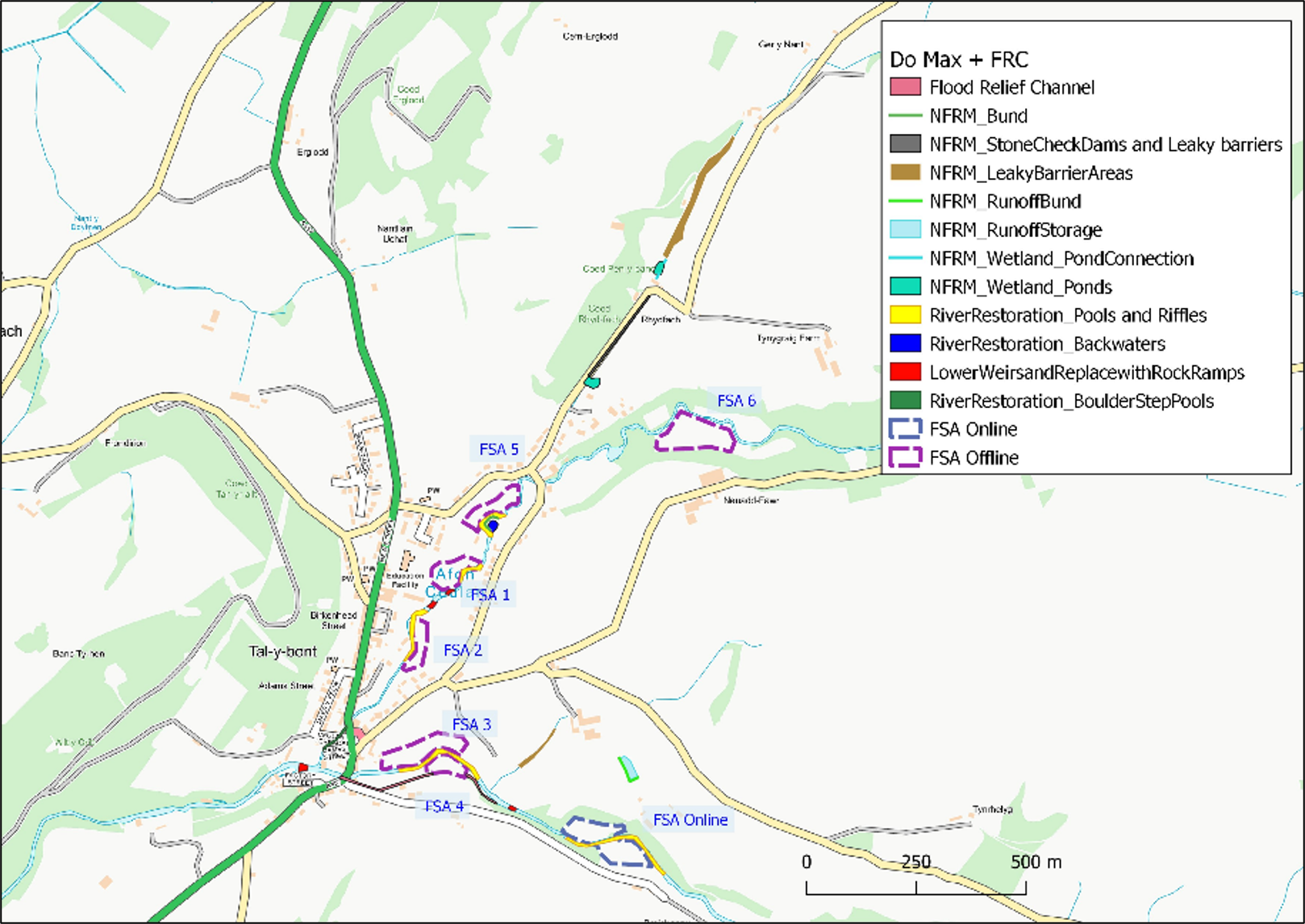
Option 4 - Do maximum, all six flood storage areas, Natural Flood Risk Management and River Restoration measures
This option would include all 6 flood storage areas, and those elements of Natural Flood Risk Management and river restoration measures that do not clash with these areas.
This is considered to be the preferred option at the moment. It protects all properties in a present day 1:10 year flood event and a total of 23 residential properties and two non-residential properties in a 1:100 year flood event. This option includes the following measures:
- 6 flood storage areas located on areas of low-lying land next to the rivers, three on the Afon Leri and three on the Afon Ceulan;
- Re-meandering of the ordinary watercourse downstream of Rhydfach and the construction of stone check dams, as well as a new pond at the downstream extent;
- Leaky woody debris dams installed in the wooded section of ordinary watercourse upstream of Rhydfach;
- New pond constructed on the upstream ordinary watercourse at Coed Pen-y-banc;
- Woody debris dams located along the ordinary watercourse that flows into the Afon Leri, south of Berthlwyd Fawr;
- An overland runoff storage bund constructed within a grazing field to the south of Berthlwyd Fawr;
- Boulder step pools along the Afon Ceulan between James Street and the A487;
- Lowering existing weirs in the upstream section of the Afon Ceulan and replacing with rock ramps;
- New backwater on the left bank of the Afon Ceulan; &
- New pool and riffle features along suitable sections of the Afon Ceulan and Leri.
Option 5 - The steps outlined in Option 4 plus Flood Relief Channel
This option builds upon the steps outlined in Option 4 above, with the addition of a flood relief channel along the route of the historic leat passing to the south of the Afon Leri just east of the A487 crossing.
How to take part in the consultation
Complete our online Talybont Flood Alleviation scheme survey.
Download a paper copy: Talybont Flood Alleviation scheme survey
You can also ask for a paper copy from your local Library or Leisure Centre, by calling 01545 570881 or emailing us at clic@ceredigion.gov.uk
Please return paper copies to your local library or to Highways and Environmental Services, Ceredigion County Council, Canolfan Rheidol, Llanbadarn Fawr, Aberystwyth, SY23 3UE.
A public engagement event will take place on February 11, 2025, in Talybont Hall from 3pm to 7pm. Consultation materials will be on display and staff will be available to answer questions from residents.
Read our Consultations Privacy Notice.
If you wish to receive the information in a different format, please contact us on 01545 570881 or email clic@ceredigion.gov.uk
What happens next?
In order to secure funding for implementing any scheme the priority must be to protect residential properties. Some commercial properties may be accommodated within the economics.
Timeline
We are looking to complete the detailed design phase, during the 2025/26 Financial Year, which will include an update to the Business Case in order to request funding to implement the preferred option. A summary of activities:
December 2024 - February 2025
- Public Consultation
- Complete Outline Business Case
January/February/March 2025
- Update Outline Business Case; &
- Submit Outline Business Case to Welsh Government, publish Outline Business Case.
April/May/June 2025 (Commencement of detailed design & Full Business Case works)
- Review potential catchment wide flood risk reduction measures;
- Undertake additional topographic survey; &
- Finalise option using hydraulic modelling.
July/August/September 2025
- Complete Ground Investigation; &
- Undertake detailed Design calculations and draft drawings.
October/November/December 2025
- Draft Detailed Design and Implementation Tender Pack; &
- Undertake further public consultation
January/February/March 2026
- Finalise Detailed Design and Implementation Tender Pack;
- Develop Full Business Case; &
- Submit Full Business Case to Welsh Government.
The Tal-y-Bont Flood Alleviation Scheme will only be implemented if we receive funding from Welsh Government in line with the current Flood Coastal Erosion Risk Management (FCERM) strategy following submission of the Full Business Case.
